How to read this list
California measures about 800 miles top to bottom, and the good news is that a lot of that distance is a reward rather than a slog. The drives below are the ones where the road itself is the point. Each entry gives the region, the mileage, and the season, because half of these close or turn dangerous in winter.
Some of these are all-day commitments and some are a two-hour detour. Pick by where your trip already sits. If you are starting from the Bay, the San Francisco Bay Area puts you within a couple of hours of three of them. For the full state picture, start at the California travel guide. Pair the Sierra drives with the best hot springs in California for a soak at the end of the day, and if you are driving in winter, check the best ski resorts in California, because most of these mountain routes are ski-season roads.
The coastal drives
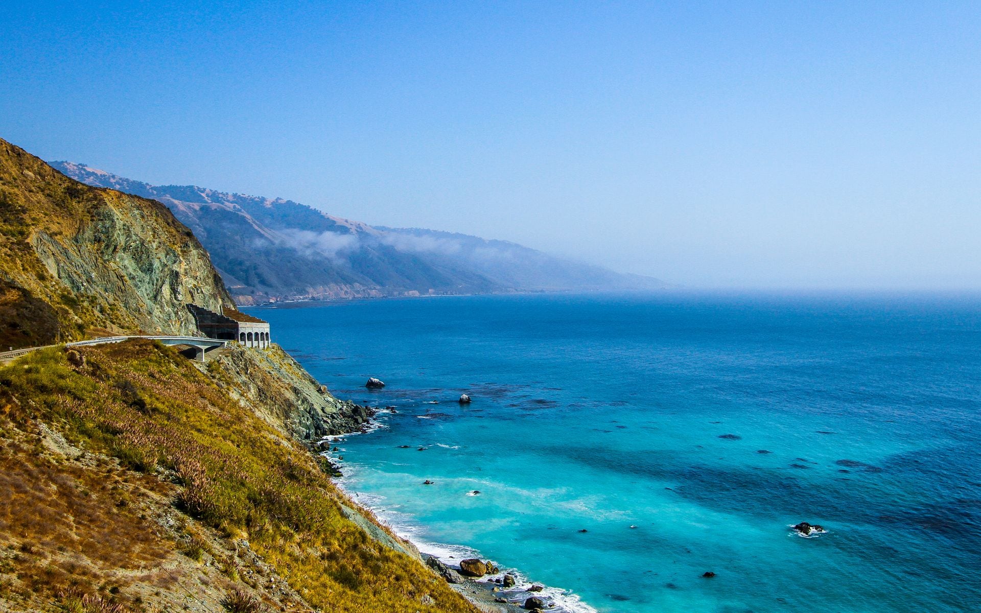
**Region: Central Coast · Length: about 90 miles · Season: year-round** Big Sur on Highway 1 between Carmel and San Simeon is the drive most people mean when they say California road trip. Bixby Creek Bridge, McWay Falls, and 40 miles of cliff-hung two-lane make it the benchmark. Allow a full day with stops, check for landslide closures before you go, and read the deeper Big Sur guide for the pullouts that matter.
**Region: Central Coast · Length: 17 miles · Fee: $12.25 per car · Season: year-round** The 17-Mile Drive loops through Pebble Beach and Del Monte Forest between Monterey and Carmel, past the Lone Cypress and the Pacific Grove shoreline. The fee is refundable as credit if you spend it at a Pebble Beach restaurant, which most people do.
**Region: San Francisco Bay Area · Length: about 20 miles · Season: year-round** Panoramic Highway over Mount Tamalpais in Marin climbs from Highway 1 at Stinson Beach to the shoulder of Mount Tam, with the Pacific on one side and the whole Bay on the other. It is a 45-minute detour from the Golden Gate that feels like a different state.
The mountain and Sierra drives
**Region: High Sierra · Length: about 46 miles · Season: roughly late May to October** Tioga Road, Highway 120 through the high country of Yosemite, tops out at 9,943 feet at Tioga Pass and runs past Tenaya Lake and Tuolumne Meadows. It is closed by snow more than half the year, so confirm the opening date before you plan around it. See the Yosemite guide for timing.
**Region: Eastern Sierra · Length: about 130 miles worth doing · Season: year-round, best summer and fall** Highway 395 up the east side of the Sierra runs under the 14,000-foot peaks from Lone Pine past Bishop to Mono Lake and Mammoth. Fall color in the aspens around late September and October is the best in the state. It links naturally to Mammoth Lakes.
**Region: High Sierra · Length: about 28 miles · Season: year-round around the lake** Highway 89 past Emerald Bay on Lake Tahoe's west shore hangs above the only island in the lake and delivers the classic Tahoe overlook. In winter the Emerald Bay stretch can close for avalanche control, so check conditions. See the Lake Tahoe guide.
**Region: High Sierra · Length: about 30 miles one way · Season: spring to fall** The Kings Canyon Scenic Byway, Highway 180, drops from the sequoia groves into a granite canyon deeper in places than the Grand Canyon, ending at Zumwalt Meadow. The lower stretch closes in winter.
The desert and northern drives
**Region: The Deserts · Length: 9-mile loop · Season: October to April** Artist's Drive in Death Valley is a one-way paved loop through hills streaked pink, green, and gold from oxidized minerals, with Artist's Palette the standout stop. It is short, so add it to a day that includes Zabriskie Point and Badwater Basin. See the Death Valley guide.
**Region: The Deserts · Length: about 30 miles · Season: year-round** The Palms to Pines Highway, Highway 74 out of Palm Desert, climbs from the desert floor to the pine forest around Idyllwild at 5,000-plus feet in under an hour, one of the fastest ecosystem changes you can drive in the state.
**Region: Greater Los Angeles · Length: about 66 miles · Season: spring to fall** The Angeles Crest Highway, Highway 2, climbs out of La Cañada into the San Gabriel Mountains above LA to over 7,000 feet. Upper sections close with winter snow. It is the quickest way to trade the city for alpine air.
**Region: North Coast · Length: 32 miles · Season: year-round** The Avenue of the Giants parallels Highway 101 through Humboldt Redwoods State Park, past the tallest trees on earth. It is free, flat, and one of the easiest wins on this list. Pair it with the Redwood National and State Parks.
Where to stay and how to plan the drive
Base your nights near the drive so you catch the good light early and late. For Big Sur and 17-Mile Drive, the Monterey Plaza Hotel & Spa and The Inn at Spanish Bay on the Monterey Peninsula put you at the north end of the coast. For Tahoe and the Sierra drives, Edgewood Tahoe Resort in South Lake Tahoe sits right on the water near Highway 89. In the city end of things, the Argonaut Hotel and the Fairmont San Francisco keep you close to the Marin routes. Compare rates in the hotels and resorts directory.
Two rules make these drives better. First, gas up before the remote ones: Death Valley, Highway 395, and Tioga Road have long stretches with no services and no cell signal. Second, check the road status the morning you go. Highway 1 closes for landslides, the Sierra passes close for snow from October into spring, and the Angeles Crest and Kings Canyon roads close their upper reaches in winter. A closed pass can add hours to your day.
Frequently asked questions
What is the best scenic drive in California?
Big Sur on Highway 1 between Carmel and San Simeon is the one most people rank first, about 90 miles of ocean-cliff two-lane with Bixby Bridge and McWay Falls. Allow a full day with stops. If you want mountains instead, Tioga Road through Yosemite and Highway 395 up the Eastern Sierra are the top picks, but both are seasonal.
When does Tioga Road in Yosemite open?
Tioga Road, Highway 120 over the Sierra, usually opens between late May and early July and closes with the first heavy snow, often in October or November. The exact dates change every year with the snowpack, so check the current-year status on the Yosemite park page before you plan a trip around it.
Is the 17-Mile Drive worth the fee?
Yes, for most people. The $12.25 per car covers the Lone Cypress, Pebble Beach, and the Del Monte Forest shoreline, and the fee is refundable as dining credit if you eat at a Pebble Beach restaurant. It pairs well with a day in Monterey and Carmel and the start of the Big Sur coast.
Which scenic drives are open in winter?
The coastal drives stay open year-round: Big Sur, 17-Mile Drive, and Panoramic Highway over Mount Tam, though Highway 1 can close for landslides. The desert drives like Artist's Drive in Death Valley are best in winter. The Sierra passes, the Angeles Crest, and the upper Kings Canyon road close with snow, so save those for late spring through fall.