What to Expect
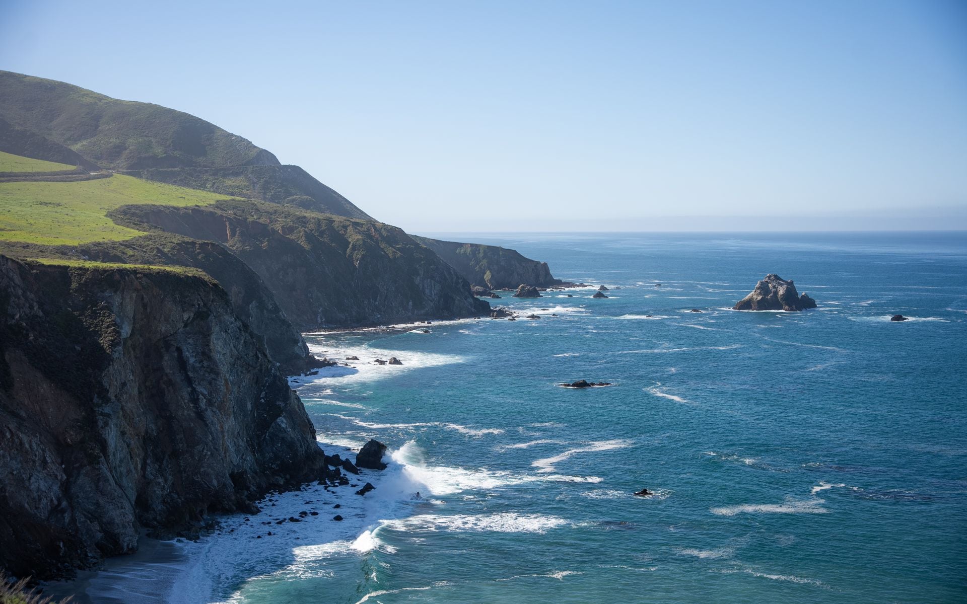
Big Sur is a region, not a town, defined by the roughly 90-mile run of Highway 1 that hangs on the cliffs between Carmel to the north and Hearst Castle and San Simeon to the south. The Santa Lucia Range rises straight out of the ocean here, so the road twists along the edge with the surf far below on one side and redwood-filled canyons on the other. Services are sparse and deliberately so: expect a few lodges, restaurants, and state parks spread out along the highway, limited and expensive fuel, and long gaps with no cell coverage.
The weather is coastal and changeable. Summer mornings often start gray with fog that burns off by afternoon, spring brings green hills and wildflowers, and fall is frequently the clearest, warmest season. Because the highway clings to unstable cliffs, landslides periodically close sections of Highway 1 for months at a time, so the single most important thing to check before any Big Sur trip is whether the road is fully open end to end.
Big Sur is the wild heart of the Central Coast, bookended by the towns of Monterey and Carmel to the north and reached from Santa Barbara up the coast to the south. It is one of the best coastal destinations in California and the defining leg of the state's scenic drives.
What to Do
The drive itself is the main event, and a handful of stops anchor it. Bixby Creek Bridge, an open-spandrel arch curving across a deep coastal canyon, is the most photographed spot on the whole route, with a pullout just north of it. Farther south, Julia Pfeiffer Burns State Park holds the region's signature view: McWay Falls, an 80-foot waterfall that drops onto a cove beach, seen from a short, easy overlook trail. Pfeiffer Beach, reached down a narrow unmarked side road, is known for its purple-tinged sand and the surf firing through Keyhole Rock at sunset.
For hiking, Pfeiffer Big Sur State Park sits in a redwood canyon with trails like the Valley View and Pfeiffer Falls loops, a good place to walk among big trees off the coast. Andrew Molera State Park to the north has beach and bluff trails where the Big Sur River meets the sea. The stretch of coast is also prime whale-watching water, with gray whales passing close in winter and spring, and Point Lobos State Natural Reserve, just north near Carmel, adds some of the finest short coastal walks anywhere in the state.
This is a place to slow down rather than rack up sights. Many visitors spend a day just driving the highway with frequent stops at the pullouts, walking a short trail or two, and timing sunset at a beach. If you want to keep going south, Hearst Castle at San Simeon anchors the far end of the drive with tours of the hilltop estate.
Getting There and Parking
Big Sur is a drive, and Highway 1 is the only road through it. From the north, it is about 30 minutes from Carmel to Bixby Bridge and roughly 2.5 to 3 hours from San Francisco to the heart of Big Sur. From the south, it is about 5 to 6 hours from Los Angeles up the coast, or faster inland via US-101 to San Simeon. The nearest airport is Monterey (MRY), about 40 minutes to the northern end, while San Francisco (SFO) and San Jose (SJC) are the larger fly-in options.
Before you commit to driving the whole route, confirm the road status. Highway 1 through Big Sur has been closed by major landslides more than once in recent years, sometimes forcing an out-and-back from either end rather than a through-drive. The California Department of Transportation posts current closures, and this can change your whole itinerary, so check it the week you travel.
Most state parks along the way charge a day-use fee of about $10 per vehicle, and the popular pullouts (Bixby Bridge, McWay Falls, Pfeiffer Beach) fill up on weekends and in summer, so arrive early. Pfeiffer Beach in particular has a small lot down a tight road that fills fast. Fuel is limited and pricey along the highway, so fill up in Carmel or Cambria before you start, and expect long stretches with no cell service.
Best Time to Go
Fall, from September into November, is often the best time on this coast: the summer fog thins, the days are warm and clear, and the crowds ease after the peak. Spring, from March into May, is the runner-up, with green hillsides, wildflowers, and full-flowing waterfalls, plus gray whales still migrating past.
Summer, June through August, is the busiest and most expensive season, and the mornings frequently start socked in with coastal fog that can hide the views until it burns off in the afternoon. It is still a fine time to go if you set expectations for the fog and book lodging well ahead, since the limited rooms sell out.
Winter, December through February, is the quietest and greenest, with the biggest surf and the best whale watching, but also the highest chance of storms and landslide-related road closures on Highway 1. If you travel in winter, keep your plans flexible and watch the road reports. Whatever the season, bring layers, because the coast stays cool and the temperature can swing sharply between sun and fog.
Where to Stay and Eat
Lodging in Big Sur is limited, memorable, and often expensive. At the high end, Post Ranch Inn and Ventana Big Sur are clifftop and ridge retreats with prices to match, aimed at a splurge stay. The Big Sur River Inn and the historic Deetjen's Big Sur Inn are the more down-to-earth options set among the redwoods along the highway. Because rooms are few and demand is high, book far ahead for any season, and expect to pay more than you would on the mainland coast.
Many visitors base instead in Carmel or Monterey to the north, where hotels are more plentiful and you can day-trip into Big Sur. The Monterey Plaza Hotel & Spa on Cannery Row and the coastal resorts around Carmel put you within an easy drive of the northern end. To the south, Cambria and San Simeon offer simpler lodging near Hearst Castle.
For food along the highway, Nepenthe is the classic Big Sur stop, a cliffside restaurant with a wide terrace looking down the coast, best for a burger or a drink at sunset. Options are few and spread out, so plan meals around the lodges and the handful of roadside restaurants, and pack water and snacks for the drive. To build a longer coastal trip, our Central Coast guide links Big Sur with Monterey, Carmel, and the road south to Santa Barbara.
Frequently asked questions
Is Highway 1 through Big Sur open?
Check before you go. Highway 1 clings to unstable cliffs and has been closed by major landslides more than once in recent years, sometimes forcing an out-and-back from one end rather than a full through-drive. The California Department of Transportation posts current closures, so confirm the road status the week you travel.
How long does it take to drive Big Sur?
The core 90-mile stretch takes a couple of hours of pure driving, but with stops at Bixby Bridge, McWay Falls, Pfeiffer Beach, and a short hike or two, most people spend a full day. From Carmel it is about 30 minutes to Bixby Bridge; from San Francisco it is 2.5 to 3 hours to the heart of Big Sur, and about 5 to 6 hours from Los Angeles.
When is the best time to visit Big Sur?
Fall (September to November) is often best, with thin fog, warm clear days, and smaller crowds. Spring brings green hills, wildflowers, and full waterfalls. Summer is busy and expensive with foggy mornings, and winter is green and quiet but carries the highest risk of storms and landslide road closures.
Can you see McWay Falls in Big Sur?
Yes. McWay Falls, an 80-foot waterfall that drops onto a cove beach, is in Julia Pfeiffer Burns State Park and is seen from a short, easy overlook trail off Highway 1. There is a day-use fee of about $10 per vehicle, and the lot fills on weekends, so arrive early. You cannot walk down to the beach itself.
Where should I stay when visiting Big Sur?
In Big Sur itself, options are limited: Post Ranch Inn and Ventana Big Sur at the high end, or the Big Sur River Inn and Deetjen's for a more down-to-earth stay, all booked far ahead. Many visitors instead base in Carmel or Monterey to the north, where hotels are more plentiful, and day-trip into the coast.