California was built for the road trip. The state is big enough that you can drive for a week and never repeat a landscape, from surf beaches to redwood forests to the lowest desert in North America. The catch is that distances here are long and traffic is real, so the best trips pick a lane instead of trying to see everything. Below are seven routes worth the drive, each with a real length, a drive time, and where to stop. For the deeper list, see best road trips in California, and to size any of these, read how many days you need in California.
1. Highway 1: San Francisco to Los Angeles
Route: SF to LA on Highway 1 · Length: ~450 miles · Time: 3–5 days
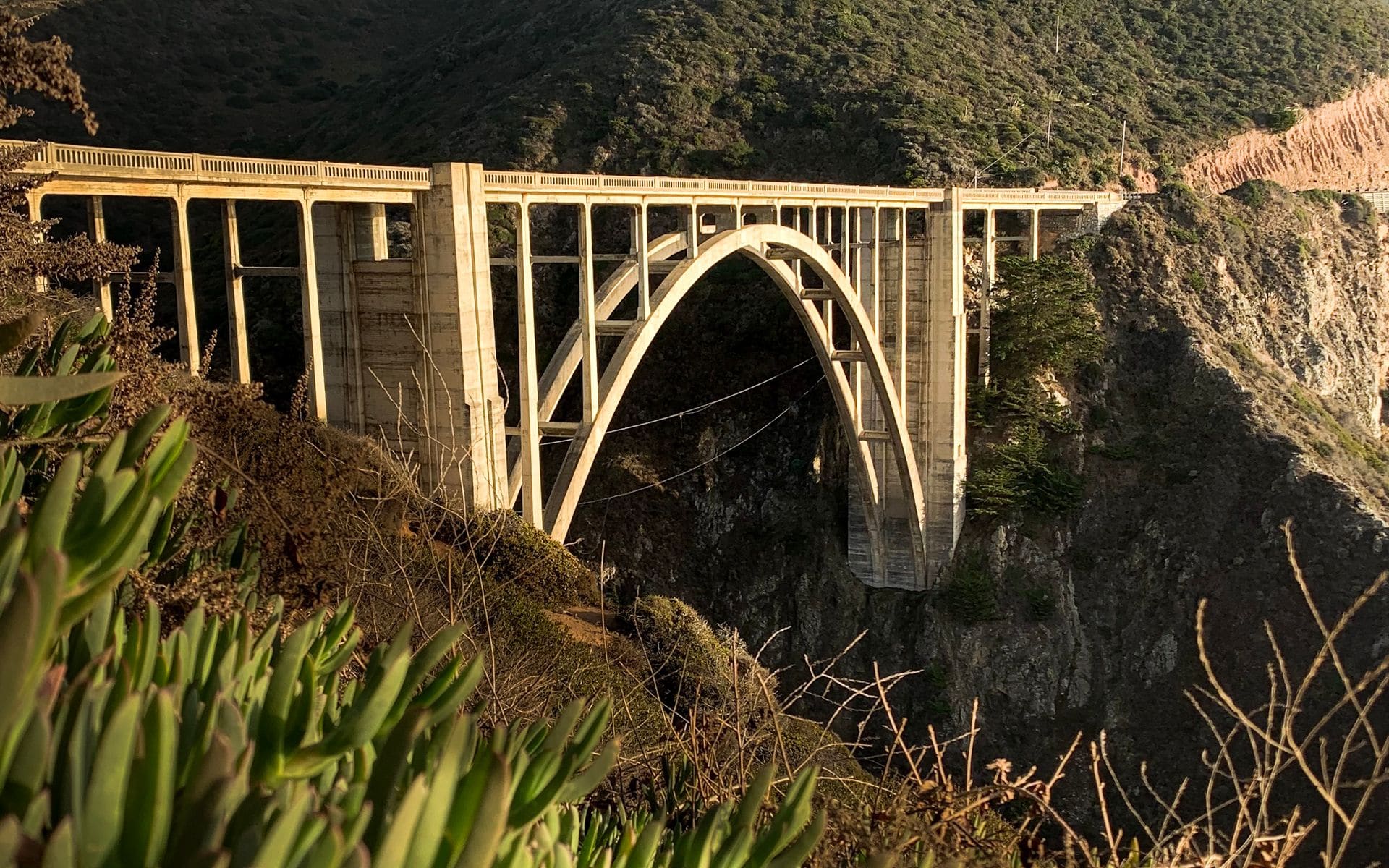
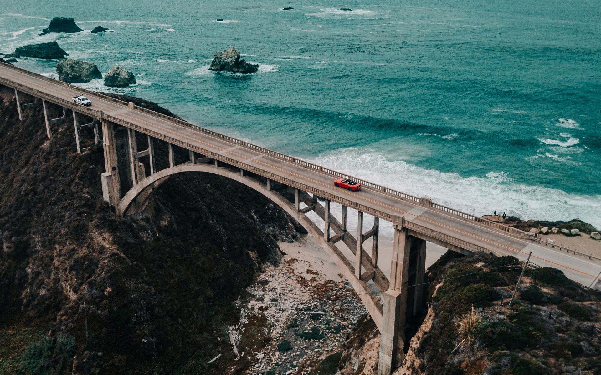
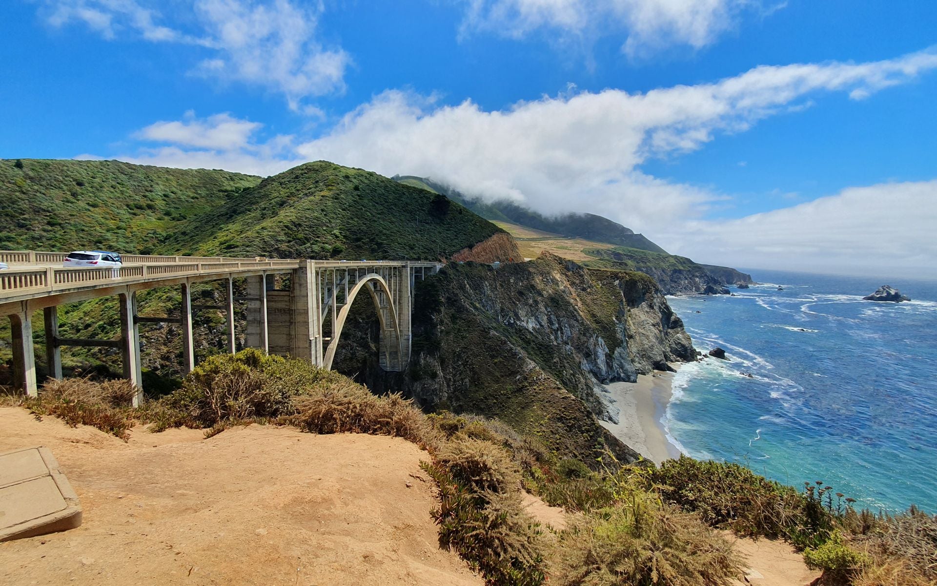
This is the one most people picture. Highway 1 hugs the coast the whole way, and the stretch through Big Sur is the payoff: Bixby Creek Bridge, McWay Falls dropping onto the beach at Julia Pfeiffer Burns State Park, and Nepenthe, the clifftop restaurant that has been serving the same ocean view since 1949. Break the drive in Monterey or Carmel, then Big Sur, then Santa Barbara. South of Big Sur, stop at the Piedras Blancas rookery near San Simeon, where thousands of elephant seals haul out on the beach a few steps from the parking lot, then tour Hearst Castle up on the hill above it. Cambria and Cayucos make good lower-key overnight stops if Big Sur’s lodges are booked, and they usually are: Post Ranch Inn and Ventana run several hundred dollars a night and sell out months ahead. Note that the road occasionally closes for slides, so check Caltrans conditions before you commit, because a closure can force a long inland detour. Do not try to do it in a day; it is 9 to 10 hours of driving without stops, versus 6 hours if you cut inland on Interstate 5.
2. The Eastern Sierra: Highway 395
Route: Up US-395 along the Sierra’s east side · Length: ~300 miles · Time: 3–4 days
Highway 395 runs along the base of the tallest mountains in the Lower 48, and it is the most underrated drive in the state. From the south you pass the Alabama Hills near Lone Pine, where a thousand Westerns were filmed under Mount Whitney, then Manzanar, the June Lake Loop, Mammoth Lakes, and Mono Lake with its otherworldly tufa towers. Detours worth the extra miles include Convict Lake near Mammoth, the ghost town of Bodie preserved in a state of arrested decay off Highway 270, and Devils Postpile National Monument, a wall of columnar basalt reached by a shuttle out of Mammoth in summer. Soak sore legs at one of the free Eastern Sierra hot springs in the Long Valley area near Mammoth, and eat at the Whoa Nellie Deli inside the Mobil station at Tioga Pass Junction, which is genuinely good despite the setting. In summer you can turn west over Tioga Pass into Yosemite’s high country. This is a warm-season route: the pass and side roads close in winter, so plan it June through October.
3. Napa and Sonoma Wine Country Loop
Route: SF north into wine country and back · Length: ~150 miles · Time: 2–3 days
An easy weekend from the Bay Area. Drive north over the Golden Gate Bridge into Sonoma and Napa, base in the town of Napa or Healdsburg, and tour tasting rooms with a designated driver or a hired car. Napa names worth booking ahead include Domaine Carneros for sparkling, Trefethen Family Vineyards, and Monticello Vineyards, and the Oxbow Public Market in downtown Napa is the low-key lunch stop between appointments. Weekends and harvest season (September into October) are the busiest, so reserve tastings in advance. Wine country makes a natural first leg before you head to the coast or the Sierra.
4. Death Valley and the Desert Parks
Route: LA or Las Vegas loop through Death Valley · Length: ~500 miles · Time: 3–4 days
Death Valley is the hottest, lowest, driest ground in North America, and it is genuinely other-worldly in the cooler months. Drive the loop from Los Angeles or pair it with Las Vegas, hitting Badwater Basin at 282 feet below sea level, the dunes at Mesquite Flat, the wind-polished rock of Artists Palette on its one-way scenic drive, and the overlook at Zabriskie Point at sunrise or Dante’s View at sunset. The park charges $30 per vehicle for seven days, the same America the Beautiful pass covers it, and the two lodging bases inside are the historic Inn at Death Valley and the more affordable Ranch at Death Valley, both at Furnace Creek and both booked far ahead in season. This is a winter trip: come October through April, because May through September regularly tops 110 degrees and midday hiking becomes dangerous. Fuel up before you enter, because services inside the park are 50 miles apart. You can string it together with Joshua Tree to the south for a full desert loop, and our Joshua Tree weekend guide covers that end.
5. Pacific Northwest Coast: Redwoods and Highway 101
Route: SF north to the Oregon border on US-101 · Length: ~350 miles · Time: 3–4 days
The North Coast is the quiet, foggy, forested version of the California road trip. Head north from San Francisco on Highway 101 through Mendocino, a clapboard village on the bluffs, then into the redwood country around Redwood National and State Parks, where the tallest trees on earth grow right beside the road on the Avenue of the Giants, a 31-mile alternate to the freeway through old-growth groves. Worthwhile stops along the way include Fern Canyon in Prairie Creek Redwoods, its walls draped in ferns and used as a filming location for a Jurassic Park sequel, the Victorian village of Ferndale, and the roadside kitsch of Trees of Mystery near Klamath. This route trades sun for scale and solitude. Summer and early fall have the most reliable weather; winter brings heavy rain to this corner of the state, which is exactly when the rivers run and the forest is at its greenest if you do not mind getting wet.
6. Tahoe and Yosemite
Route: Sacramento or Bay Area to Tahoe and Yosemite · Length: ~400 miles · Time: 4–5 days
Two of the Sierra’s headliners in one loop. Start at Lake Tahoe for the alpine water and, in winter, the skiing, then drop south to Yosemite Valley for the granite walls and waterfalls. In summer you can connect the two over Tioga Pass; in winter that pass is closed and you go the long way around. Timing matters more here than on any other route, so weigh Lake Tahoe in summer versus winter before you set the dates. Yosemite has used a peak-season day-use reservation system in recent summers, so check the current rules.
7. San Diego to Los Angeles Beach Run
Route: SD north to LA along the coast · Length: ~120 miles · Time: 2 days
The mellow one. Southern California’s beach towns line up along the coast from San Diego through La Jolla, the surf breaks of Encinitas and San Clemente, Laguna Beach, and Newport before you reach Los Angeles. Stop at Torrey Pines State Natural Reserve for the cliff-top trails above La Jolla, watch the hang gliders at the Torrey Pines Gliderport, and pull into Crystal Cove State Park between Laguna and Newport for a walkable beach and the historic cottages. It is about 2 hours of driving without traffic, so the point is to stretch it over a couple of days and stop to swim and eat. This is the easiest route on the list and the best for a first California trip with kids.
What to Know Before Any of These
A few things apply to every route here. Distances on a California map lie: the state is 800 miles top to bottom, and a drive that looks like an afternoon is often a full day once you factor terrain and traffic. Los Angeles and the Bay Area both have brutal rush hours, so time your departures to leave the metros mid-morning or mid-afternoon, not at 8 a.m. or 5 p.m. Gas is the most expensive in the country here, routinely $1 to $1.50 a gallon over the national average, and it climbs higher in remote spots like Death Valley and the Eastern Sierra, so fill up in towns rather than at the last outpost before a park.
Reservations are the other trap. Yosemite has used a peak-season day-use reservation in recent summers, the popular Big Sur and Death Valley lodges book months out, and campgrounds across the state release on recreation.gov on a rolling window that spring and summer travelers should mark on a calendar. Cell service drops out for long stretches on Highway 1, Highway 395, and inside every desert park, so download offline maps before you lose signal. And check Caltrans QuickMap for closures before any mountain or coastal leg, because a single slide or snowstorm can rewrite your route on the day.
How to Pick and Plan
Choose by season and by what you want. The desert parks are winter trips, the Eastern Sierra and Tioga Pass are summer trips, and the coast works most of the year. If you are deciding between the two halves of the state, our take on northern versus southern California helps you commit. Almost all of these need your own vehicle, so line that up first with renting a car in California, pin your dates using the best time to visit California page, and use the California travel guide to fill in the rest.