Before You Pick a Route
Two things shape every California road trip: distance and season. The state runs about 800 miles top to bottom, so San Francisco to Los Angeles is roughly 6 hours on Interstate 5 or 9 to 10 on Highway 1, and you cannot see it all in one loop. Season matters just as much: the Sierra passes close under snow from late fall into spring, and the deserts are only comfortable October through April. Pick a route that matches your dates.
A rental car is effectively required for all of these outside the core of San Francisco. Our California Travel Guide lays out the regions each route crosses, the hotels and resorts directory covers overnight bases, and several of these routes start or end in the San Francisco Bay Area.
The Coast
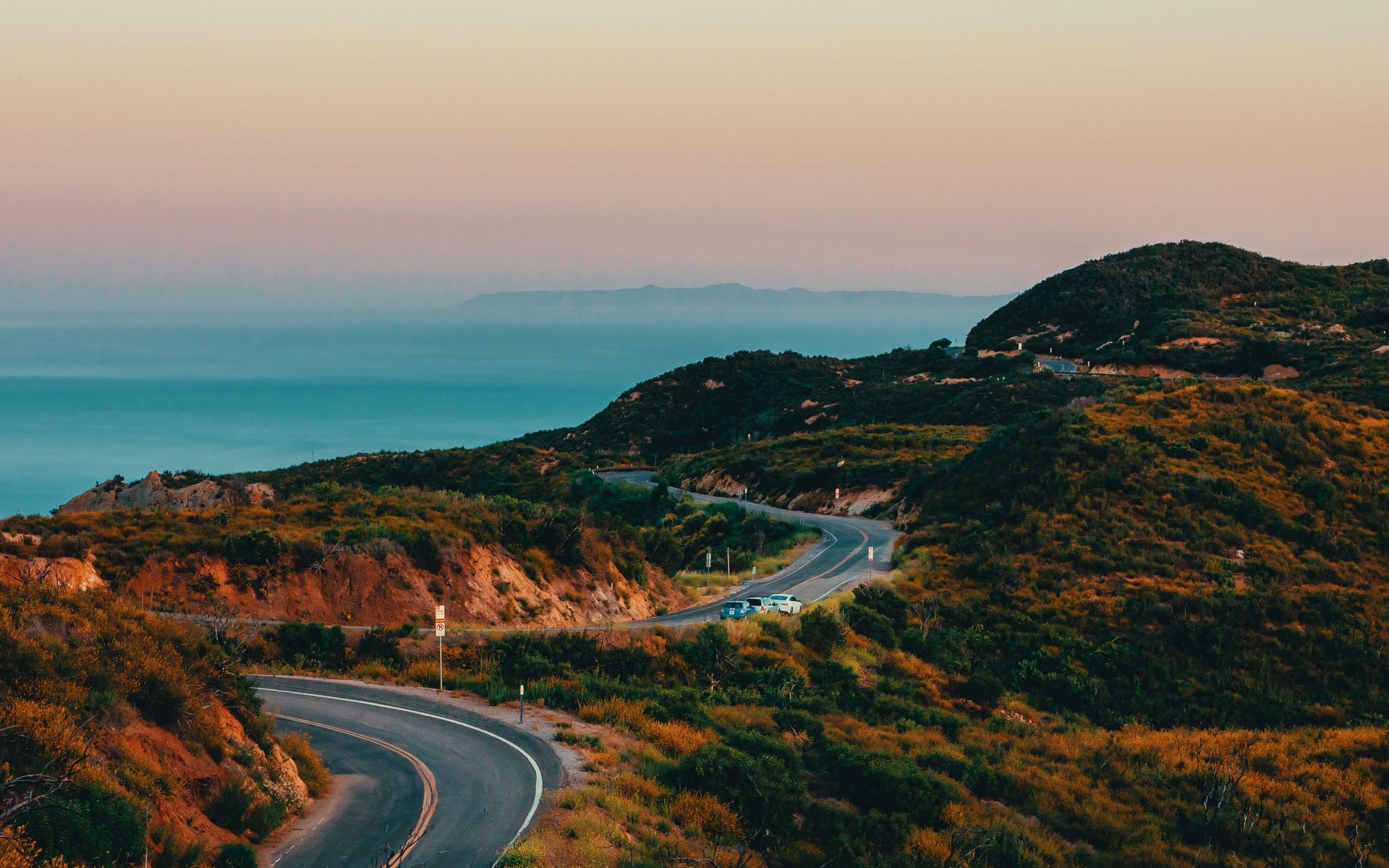
**Route: Pacific Coast Highway, SF to LA · Distance: ~450 mi · Time: 3–5 days**. The Highway 1 run from San Francisco to Los Angeles is the classic California road trip: Santa Cruz, Monterey, the Big Sur cliffs, Hearst Castle, and Santa Barbara, all strung along the ocean. Do not rush it into a day; the road is slow and winding through Big Sur, and the point is to stop. Plan overnights in Monterey and Santa Barbara at minimum.
**Route: Highway 1 North, SF to Mendocino · Distance: ~175 mi · Time: 2–3 days**. North of San Francisco, Highway 1 gets wilder and emptier: Point Reyes, the Sonoma Coast, and the headland village of Mendocino, with far fewer cars than Big Sur. Continue to the redwoods and Avenue of the Giants if you have a fourth day. This is the coast for travelers who want drama without the crowds.
**Route: Avenue of the Giants · Distance: ~32 mi · Time: half a day**. This old two-lane highway parallels US-101 through Humboldt Redwoods State Park on the North Coast, running under some of the tallest trees on earth with pullouts for short grove walks like Founders Grove and the Rockefeller Forest. Tack it onto the end of a Highway 1 North drive; it is the single best stretch of redwoods you can see from behind the wheel.
**Route: San Francisco to Los Angeles, the scenic way · Distance: ~500 mi · Time: 4–5 days**. Combine the coast south with inland detours: this is the trip that lets you fold in Big Sur, a Central Coast wine stop near Paso Robles, and the beaches of the south. It links naturally into a wider coastal towns tour.
**Route: Napa and Sonoma wine loop · Distance: ~120 mi · Time: 2–3 days**. Just north of San Francisco, cross into Napa Valley on Highway 29, work up through the tasting rooms to Calistoga, then loop back down the quieter Sonoma Valley on Highway 12. Keep the driving legs short and the tastings spaced, and line up a designated driver or a car service, since the valley roads are patrolled and the pours add up fast. It threads neatly into a stop from our best wineries guide.
The Sierra and the Eastern Side
**Route: Highway 395, the Eastern Sierra · Distance: ~300 mi · Time: 3–4 days**. Highway 395 up the dry east side of the Sierra is one of the great overlooked drives in the West: Mono Lake's tufa towers, Mammoth Lakes, Bishop, the Ancient Bristlecone Pine Forest, and the highest peaks in the lower 48 rising straight off the valley floor. Best from late spring through fall, since winter storms close the high side roads.
**Route: Tioga Road across Yosemite · Distance: ~60 mi of pass road · Time: a full day**. Highway 120's Tioga Road climbs through Yosemite's high country to Tuolumne Meadows and drops to Mono Lake, one of the most scenic mountain crossings in the state. It only opens roughly late May or June through October, so check the current-year opening before you plan around it. It connects the Sierra to Highway 395 beautifully.
**Route: Tahoe Rim Loop · Distance: ~72 mi around the lake · Time: 1–2 days**. The drive around Lake Tahoe on Highways 89 and 50 circles the whole lake past Emerald Bay, one of the most photographed spots in the state. Add Truckee and the north-shore beaches, and it makes an easy weekend loop in the High Sierra.
The Deserts and the South
**Route: Death Valley Loop · Distance: ~300 mi round trip from Vegas or LA · Time: 2–3 days**. A loop through Death Valley hits Badwater Basin at 282 feet below sea level, Zabriskie Point at sunrise, the Mesquite Dunes, and the painted hills of Artists Drive. Only attempt it October through April; summer heat past 120 Fahrenheit makes it genuinely dangerous. Carry water and watch your fuel range between the few stations.
**Route: Joshua Tree and Palm Springs · Distance: ~200 mi loop from LA · Time: 2–3 days**. Pair the boulders and twisted trees of Joshua Tree with a soak-and-golf base in Palm Springs for the easiest desert road trip from Los Angeles. Best October through April. It is a natural companion to a Death Valley run for a full desert-parks week.
**Route: San Diego to Anza-Borrego · Distance: ~90 mi one way · Time: 1–2 days**. From the coast, climb through the mountain town of Julian and drop into Anza-Borrego Desert State Park, the largest state park in California, famous for its spring wildflower blooms in good rain years. It is the quiet desert road trip, easy from San Diego.
Building Your Own Loop
For a first California trip, the Pacific Coast Highway from San Francisco to Los Angeles is the obvious pick, and you can extend it inland to a national park on either end. If you are visiting in winter, skip the Sierra and build a desert loop through Joshua Tree, Palm Springs, and Death Valley instead. In summer and fall, the Eastern Sierra on Highway 395 is the best drive in the state and the least crowded of these routes.
Whatever you choose, book your overnights ahead through the hotels directory, and give yourself more time than the raw mileage suggests, because the good roads here are slow on purpose. If you want to add trail days along the way, our best hikes guide covers routes near every one of these drives, and the best state parks list adds stops the interstate skips.
Frequently asked questions
What is the best road trip in California for first-timers?
The Pacific Coast Highway from San Francisco to Los Angeles on Highway 1. It covers roughly 450 miles of coast past Monterey, Big Sur, Hearst Castle, and Santa Barbara. Give it three to five days rather than trying to drive it in one, since the Big Sur section is slow and the stops are the whole point.
How long does it take to drive from San Francisco to Los Angeles?
About 6 hours direct on Interstate 5 through the Central Valley, or 9 to 10 hours on Highway 1 along the coast if you drive it straight through. Nobody should drive the coast route straight through, though. Plan on three to five days with overnight stops to enjoy it.
When can I drive Tioga Road across Yosemite?
Roughly late May or June through October, depending on the snow year. Tioga Road (Highway 120) climbs to nearly 10,000 feet and closes all winter. Always check the current-year opening date with the park before planning a route that depends on it, since heavy snow years push the opening into July.
Is a desert road trip safe in California?
Yes, from October through April, when the deserts are pleasant. Avoid Death Valley and Joshua Tree in summer, when highs pass 100 to 120 Fahrenheit. Year-round, carry plenty of water, start with a full tank because gas stations are far apart, and do not rely on cell service in the parks.