What Defines the Shasta Cascade
The Shasta Cascade is California's least-crowded corner, a volcanic highland in the far north where the Cascade Range dips down from Oregon. It is defined by two mountains and a lot of water. This is not coastal California and it is not the Sierra; it is high-country forest, volcanic geology, and reservoirs, hours north of the Bay Area with a fraction of the visitors. If you want national-park scenery without the Yosemite crowds, this is where you find it, and it is the least-visited region in our California travel guide.
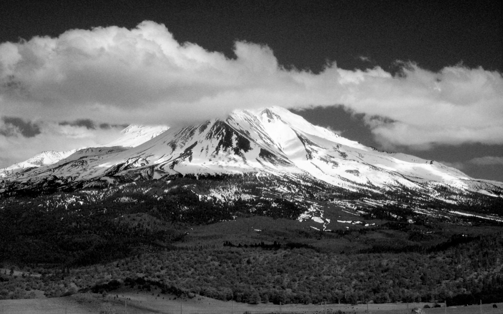
The headliner is Mount Shasta, a 14,179-foot volcano that stands alone above the I-5 corridor and dominates the skyline for a hundred miles in every direction. To the south, Lassen Volcanic National Park holds all four types of volcano and the largest plug-dome volcano on earth, plus boiling mud pots and steaming fumaroles that make it California's answer to Yellowstone on a smaller scale. Between and around them sit Lake Shasta, Burney Falls, and the city of Redding, the region's hub.
The region runs on a mountain calendar. Snow closes the high roads through Lassen for much of the year, and the best window is short. Come in summer and fall and you get the full range; come in winter and much of it is shut. Plan around the snow.
Main Bases and Towns
Redding is the practical base for the whole region. It is the largest city in the far north, sits right on I-5, and has the widest range of hotels, restaurants, and services. From Redding you are within an hour or so of Lassen's north entrance, Lake Shasta, and Whiskeytown, which makes it a good hub for day trips in several directions. The Sundial Bridge, a striking pedestrian span over the Sacramento River, and the Turtle Bay Exploration Park sit right in town for an easy afternoon.
For the mountain itself, the town of Mount Shasta on I-5 is the base of choice: a small outdoorsy town at the foot of the volcano with inns, cafes, and outfitters, plus quick access to the mountain's trailheads and the headwaters springs. Nearby Dunsmuir and McCloud are smaller, quieter alternatives with historic character and easy reach to McCloud's series of waterfalls.
For Lassen, the gateways are Mineral and Chester near the park's south entrance and the Manzanita Lake area at the north. In-park lodging is limited, so most visitors stay in Redding or the nearby entrance towns and day-trip in. Book ahead in summer; rooms in this region are fewer and fill on peak weekends. For the statewide lodging picture, see where to stay in California.
Top Places to Prioritize
Lassen Volcanic National Park is the one to build a trip around. The park highway climbs past Sulphur Works and Bumpass Hell, a boardwalk loop through boiling springs and fumaroles, and lets strong hikers summit the Lassen Peak trail for a big view over the whole volcanic country. Manzanita Lake at the north end is the gentle counterpoint, with an easy shoreline loop and reflections of the peak. Give the park a full day at minimum.
Mount Shasta itself anchors the northern half. You do not have to climb it to enjoy it: drive the Everitt Memorial Highway up the flank for the views, visit the headwaters springs in the town park, and hike the lower trails through the forest. Just east, McArthur-Burney Falls Memorial State Park protects Burney Falls, a 129-foot waterfall fed by underground springs that runs full even in late summer, and it is one of the most photographed spots in the north.
Round it out with water. Lake Shasta behind Shasta Dam is the region's big recreation lake, good for houseboats, swimming, and the Lake Shasta Caverns tour, and Whiskeytown near Redding adds swimming and waterfalls close to the hub. When you want to trade the mountains for the ocean, the best beaches in California are a long drive west, but the Shasta Cascade is a region you visit for the volcanoes and lakes, not the coast.
When to Go and How Long
Summer and early fall, roughly late June through October, is the season. That is when the Lassen park highway is reliably open, the trails are clear of snow, and the lakes are warm enough to swim. July and August are the peak and the warmest, with hot days down in Redding often in the 90s or higher, and cooler air up at elevation. September and October bring thinner crowds and pleasant days.
Winter reshapes the region. Heavy snow closes the through-road across Lassen, typically from late fall until early summer, and while the mountain towns stay open for snow play and quiet stays, the park's main scenery is not accessible by car. If your trip is built around Lassen, aim for the summer window and check road status before you go, because the highway can open late after a big snow year.
For length, plan two to four days. A tight version is a day at Lassen and a day around Mount Shasta and Burney Falls. Add a third or fourth day for Lake Shasta, Whiskeytown, and the drives, and you have a relaxed long weekend. The region is spread out, so budget driving time between the highlights.
Getting There and Around
Interstate 5 is the backbone, running straight up the middle of the region past Redding, Dunsmuir, and the town of Mount Shasta. From San Francisco or Sacramento you drive: Redding is about three-and-a-half hours from San Francisco and two-and-a-half to three from Sacramento, and the town of Mount Shasta is about an hour farther north. Redding has a small airport (RDD) with limited flights, but most visitors arrive by car as part of a longer northern-California loop.
Once here, you need a car for everything; there is no useful transit between the parks and towns. The routes are scenic and mostly easy, but the high park roads are seasonal, so check whether the Lassen highway and any high forest roads are open before you plan a specific drive. Fill your tank in Redding or the mountain towns before long stretches, and in winter carry chains for the higher elevations.
The Shasta Cascade works well as the northern end of an I-5 road trip or as a quiet counterpoint to the busy Sierra parks. It asks for a little more driving and a summer visit, but in return you get volcanic scenery, real waterfalls, and open country with almost none of the crowds you fight for farther south.
Frequently asked questions
How far is the Shasta Cascade from San Francisco?
Redding, the region's hub, is about three-and-a-half hours north of San Francisco on I-5, and roughly two-and-a-half to three hours from Sacramento. The town of Mount Shasta is about an hour farther north. Redding has a small airport (RDD), but most visitors arrive by car as part of a northern-California loop.
When is the best time to visit Lassen and Mount Shasta?
Late June through October. That is when the Lassen park highway is reliably open, the trails are clear of snow, and the lakes are warm. July and August are the warmest and busiest; September and October bring thinner crowds. Winter snow closes the through-road across Lassen, so a summer visit is essential if the park is your focus.
How many days do you need in the Shasta Cascade?
Two to four days. A tight version is a day at Lassen Volcanic National Park and a day around Mount Shasta and Burney Falls. Add a third or fourth day for Lake Shasta, Whiskeytown, and the drives between them for a relaxed long weekend. The region is spread out, so budget driving time.
Is the Lassen park road always open?
No. Heavy snow closes the main highway through Lassen Volcanic National Park, typically from late fall until early summer, and after a big snow year it can open late. The mountain towns stay open year-round for quiet stays and snow play, but the park's core scenery is only reachable by car in the summer season. Check road status before you go.
What are the top things to do in the Shasta Cascade?
Hike Bumpass Hell and Manzanita Lake in Lassen Volcanic National Park, take in Mount Shasta from the Everitt Memorial Highway, see the spring-fed Burney Falls, and get out on Lake Shasta with a houseboat or the Lake Shasta Caverns tour. Redding's Sundial Bridge and Whiskeytown's swimming and waterfalls round out an easy trip.