Death Valley is the hottest, lowest, and driest place in North America, and the single most important planning decision is when you go. Get the timing right and it is one of the most rewarding parks in California. Get it wrong and you are looking at 120-degree afternoons where a short walk becomes a genuine safety risk. The answer for almost everyone is simple: visit between October and April. Here is the month-by-month reality and how to plan around the heat.
The Short Answer: October Through April
Death Valley’s comfortable season runs from October through April, and the peak visiting months are November, December, February, and March. In this window, daytime highs at Furnace Creek generally sit in the 60s to 80s Fahrenheit, which is warm but workable for hiking, driving the scenic roads, and walking out onto the salt flats at Badwater Basin. Nights get cold in winter, dropping into the 40s and sometimes near freezing, so pack layers even though it is a desert.
The park does not require timed-entry reservations, unlike Yosemite, so you can show up when you like. The entrance fee is $30 per vehicle and is valid for seven days; if you are visiting more than one national park this year, the $80 America the Beautiful annual pass pays for itself fast. There is no staffed entrance booth on most roads into the park, so pay at a self-serve kiosk or online and keep the receipt on your dash. Our Death Valley National Park page covers the individual sights and roads in more detail, and the wider national parks guide puts Death Valley alongside California’s other eight parks and their seasons.
Month by Month
Here is how the year breaks down for a visitor:
| Month | Daytime highs (Furnace Creek) | Crowds | What it means for you |
|---|---|---|---|
| October | Mid-90s cooling to 80s | Building | Shoulder month. Still warm early, comfortable by late October. |
| November | 70s–low 80s | Moderate | Excellent. Warm days, mild nights, great hiking. |
| December | Mid-60s | Light | Cool and quiet. Cold nights near freezing. Good for driving and short hikes. |
| January | Mid-60s | Light | Coolest month. Chilly nights, occasional rain, calm and uncrowded. |
| February | 70s | Moderate | Peak begins. Great weather, possible early wildflowers. |
| March | High 70s–80s | Heavy | Peak season. Best weather, best bloom odds, busiest weekends. |
| April | 80s–90s | Moderate | Doable early, heating fast. Book hikes for the morning by mid-month. |
| May–September | 100s to 120s+ | Very light | Dangerous. Avoid hiking; treat it as a drive-through at most. |
Getting there shapes when you go too. The fastest approach for most travelers is from Las Vegas, about two hours east, which makes McCarran the practical fly-in airport even though the park sits in California. From Los Angeles it is a four to five hour drive, and from the eastern Sierra you can come in over the mountains when the passes are clear. Because the closest services are sparse in every direction, aim to arrive with a full tank and daylight to spare rather than rolling in after dark on empty.
Spring is the wildcard for one reason: wildflowers. After a wet winter, Death Valley can produce a broad bloom of desert gold and other flowers across the alluvial fans, usually peaking from mid-February into April depending on elevation. A true widespread bloom happens only every several years and cannot be promised, but even an average spring brings scattered color. If flowers are your goal, aim for late February through March and check the park’s current bloom reports before committing.
Why Summer Is a Genuine Hazard
This is not caution for its own sake. Death Valley recorded a high of 134 degrees Fahrenheit at Furnace Creek in 1913, and summer afternoons routinely pass 120. The National Park Service closes many hiking trails below sea level during summer for good reason: people have died on short walks here. If you do pass through between May and September, the rules are firm. Stay on paved roads, keep the car fueled because service stations are far apart, carry far more water than you think you need (at least a gallon per person per day), and do not hike after mid-morning. Watch your vehicle’s temperature gauge on the climbs, and never rely on cell signal, which is absent across most of the park.
Even in the good season, the desert demands respect. Fill your tank whenever you can, download offline maps, and carry water on every drive. Fuel range matters more here than in almost any other park in the country.
What to See Once You Time It Right
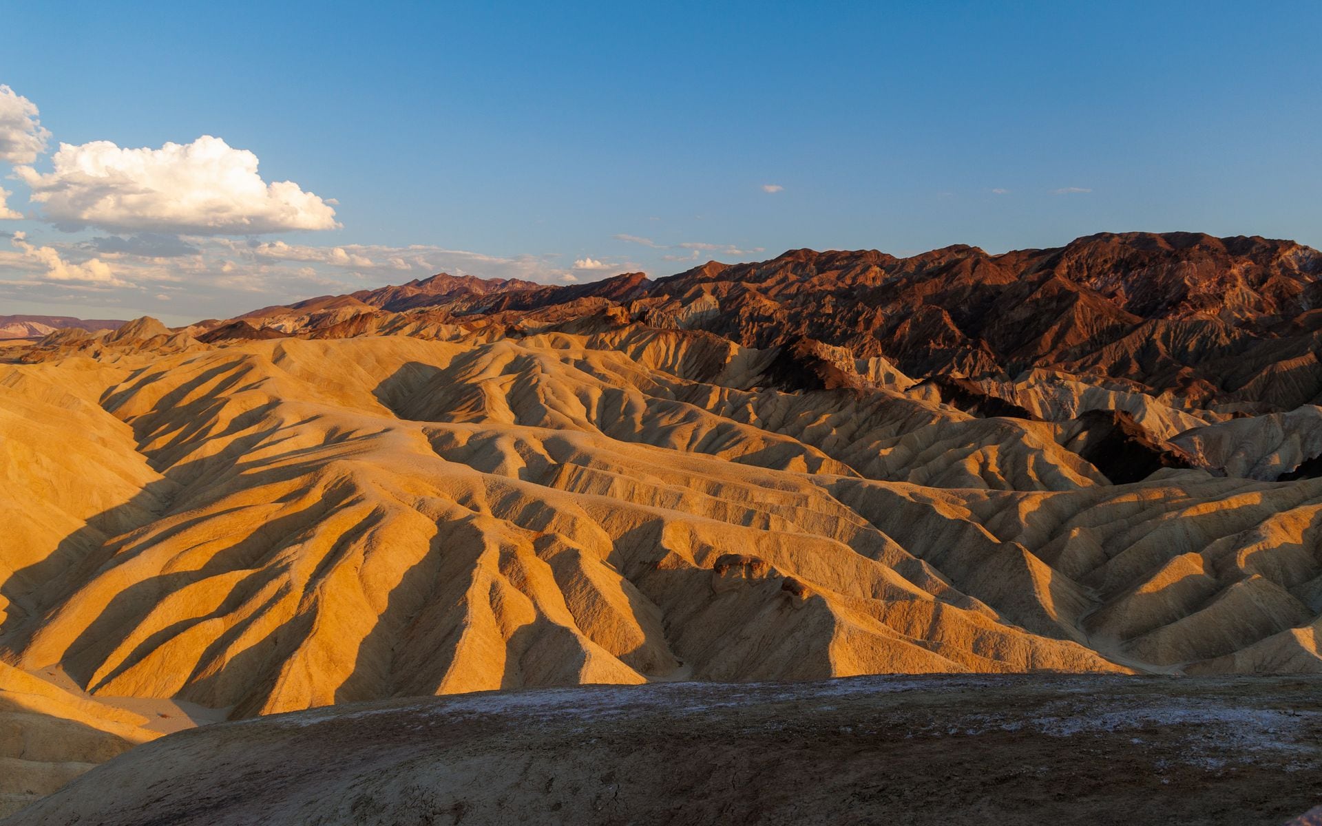
With the weather on your side, the park opens up. Sunrise at Zabriskie Point over the golden badlands is the classic first stop, and it is a short walk from the parking area. Badwater Basin sits at 282 feet below sea level, the lowest point in North America, where you can walk out onto the cracked salt flats. The Mesquite Flat Sand Dunes near Stovepipe Wells are easy to reach and best at dawn or dusk. Artists Palette is a short scenic loop drive through mineral-streaked hills, and Dante’s View, at about 5,475 feet, looks straight down onto the salt basin from a cool overlook that stays comfortable even when the valley floor bakes.
For hiking, Golden Canyon is the accessible classic: a flat-bottomed wash near Furnace Creek that you can turn into a short out-and-back or a longer loop up to the Red Cathedral formation and around to Zabriskie Point. Just off Badwater Road, the Natural Bridge trail is a quick half-mile walk to a rock arch, and the Devils Golf Course is a pull-off onto jagged, ankle-breaking salt spires that are worth a careful look. In the cool months only, Darwin Falls near Panamint Springs is a genuine spring-fed waterfall in the desert, reached by a rocky two-mile round trip.
The far corners reward a second day and a willingness to drive dirt. Ubehebe Crater, a 600-foot-deep volcanic crater at the north end, is a 50-mile haul from Furnace Creek but easy to reach on pavement. The Racetrack, with its famous sailing stones, sits beyond it down 27 miles of washboard road that requires a high-clearance vehicle and a full-size spare; do not attempt it in a rental sedan. Telescope Peak rises to 11,049 feet above the west side and usually wears snow in winter, a reminder of how much vertical range the park covers.
Give the park at least two full days if you can. The distances inside Death Valley are large, and the good light for the badlands and dunes comes at the ends of the day, so a single rushed afternoon does not do it justice. Our guide to the best time to visit California puts the desert season in context with the rest of the state, since the timing here is nearly the opposite of the coast and the mountains.
Where to Stay and Fuel Up
Lodging inside the park is limited to a handful of options, and they book out for winter and spring weekends months ahead. The Inn at Death Valley is the historic, upscale choice at Furnace Creek, with a spring-fed pool and a price tag to match. The Ranch at Death Valley next door is the more affordable family-oriented sister property with cabins, a saloon, and a general store. Stovepipe Wells Village sits in the center of the park near the dunes and runs simpler motel rooms plus the park’s cheapest gas. Out west, Panamint Springs Resort is a rustic base near Darwin Falls. If nothing inside is available, the town of Beatty, Nevada, is about 45 minutes from Furnace Creek and has cheaper motels.
Campers have three developed options near Furnace Creek: the reservable Furnace Creek Campground and the first-come Sunset and Texas Springs sites, all busiest in the cool season. Wherever you sleep, treat fuel as the real constraint. Gas inside the park runs well above the California average, and stations are far apart, so fill the tank at Furnace Creek or Stovepipe Wells whenever it drops below half. Our what to pack for California list covers the desert essentials, but for Death Valley the non-negotiables are water, a paper map, and a full tank.
Fitting It Into a Desert Trip
Death Valley pairs naturally with the other desert parks in the same cool-weather window. Joshua Tree sits a few hours south and runs on the same October-through-April rhythm; the Joshua Tree weekend guide covers how to build that leg. If you are trying to decide between a desert trip and a mountain one, the seasons pull in opposite directions, and the Lake Tahoe summer vs winter breakdown shows how the high country flips the calendar. For the wider planning picture and how the regions connect, start with the California travel guide.
The rule is easy to remember. Death Valley in winter and spring is one of the best parks in California. Death Valley in summer is a place to admire from an air-conditioned car and little more. Plan for October through April, book your lodging early, and carry more water than you think you need.